Get regular maritime industry insights!
Join thousands of industry leaders today who have already signed up to receive the latest insights.
sign up
 )
)
 )
)
 )
)
 )
)
 )
)
 )
)
 )
)
 )
)
 )
)
Taking thoughtful decisions combining ship position and weather data

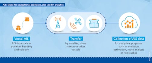
AIS was originally implemented as an anti-collision information system supplementing radar. It uses channels in the maritime VHF band to transfer ship identity, type, position, course, navigational status and other safety-related data to other ships, shore stations and satellites within range. Ships above a certain size in international trade are required to be equipped with an AIS system. Since the introduction of AIS around 15 years ago, AIS data have been collected and stored. These data are valuable for a variety of analytical purposes today and in future years.

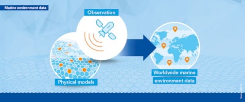
Today, global wave, wind, air humidity, temperature, ice and current velocity data are readily available. The data is estimated using climate models that combine observations with physical models. Observations consist of satellite earth observations and in-situ readings (drifting or moored buoys, aircraft, ship and land-based stations). Information on ambient conditions at sea is therefore available for nearly any location in the world.

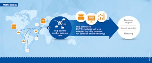
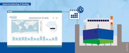
Combining worldwide marine environment data with a ship’s position data produces specific weather exposure data for the ship. Provided that the vessel is equipped with AIS, our Nerves of Steel technology, which DNV GL developed in-house, can deliver weather exposure data for every ship dating back to 2013. At an aggregated level, entire fleets can be evaluated. Weather exposure data can then be fed into various types of mathematical or physical models to calculate ship response, hull condition or fuel efficiency. Furthermore, the interpreted results can provide valuable input, for example for decision support, documentation and planning.

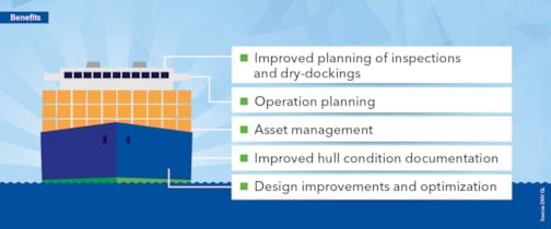
Weather exposure data in combination with experience and analytical models can benefit shipowners and other stakeholders by providing various types of decision support.

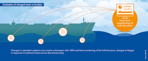
AIS and weather data used in hydrodynamic and structural models provide insight into the loads the hull structure has been exposed to over time. Real-time hull condition monitoring systems from DNV GL can identify and monitor high-risk locations in the structure. This information enables the planning of targeted and cost-efficient maintenance and inspection schemes. Taking a risk-based approach to optimizing the inspection regime increases inspection efficiency and reduces non-essential off-hire time. The inspection intervals can be increased, and the inspection scope can be reduced.

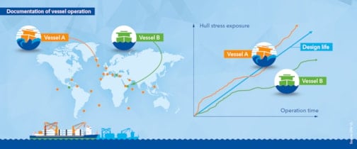
Vessel A and vessel B are sister vessels, built to the same design. They have different trading patterns, and vessel A has experienced more severe weather conditions than vessel B. As a result, it can be documented that vessel A has less fatigue life left compared to vessel B and its design life. For a ship-owning company, being able to identify the ambient conditions its vessels have been exposed to can enhance the value of its documentation. Well-documented maintenance regimes and control of structural integrity is a competitive advantage vis-à-vis charterers or cargo owners. Other processes that can benefit from this information include the selection of vessels for additional monitoring, conversion, life extension or relocation of trade. In a sales process it is possible to document operation well within design limits as well as performance benchmarked to the world fleet or sister vessels. Mild operation conditions, successful weather routing or good seamanship can be quantified.

DNV GL’s virtual hull condition monitoring system uses a digital twin of the asset, exposing it to the same loads and accelerations as the physical ship itself while applying a combination of computer-generated modelling data and real-time weather data. If desired, sensors can be installed on the ship to supply additional real-time information.

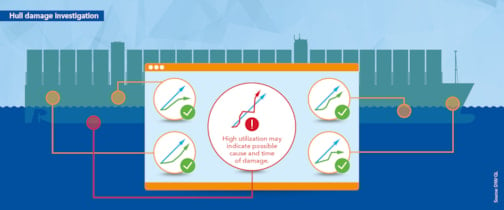
Position-specific weather information can also be used in hull damage investigations. Key input information includes vessel speed combined with the wave and wind conditions it operated in prior to the damage. Based on an evaluation of this information, DNV GL experts can provide advice on measures such as structural strengthening or operational changes.

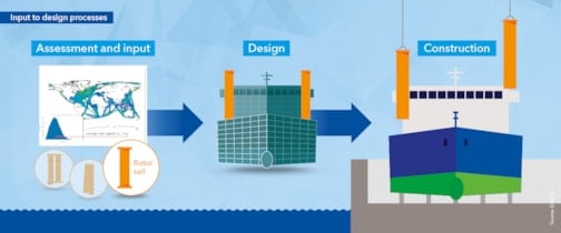
For newbuilds or vessels undergoing energy-saving optimization measures, the weather conditions on their intended routes is key information. More accurate sea margins along with wave and wind data can help determine the hull shape, optimize the bulb design, or determine the energy-saving potential of wind-assisted propulsion.
Join thousands of industry leaders today who have already signed up to receive the latest insights.
sign up